
C4C offered a survey starting a few months ago. It was intended to gauge interest in existing infrastructure possibilities and other possibilities as well. Here’s a summary of the results.
~


And here are the free response responses in plain text and C4C’s response in italics.
Something needs to be done on 9th St. between College (where the bike lane ends) and Baseline. Cyclists are constantly continuing up 9th from College to Baseline. This street is too busy and crowded for that, but I unfortunately don’t have any suggestions other than to maybe put up signs??
#
Good point, however, C4C’s focus is rural, unincorporated Boulder County. This falls within the City of Boulder. Community Cycles or the City of Boulder itself are a big help and both of them will listen to constructive comments like this.
#
Parallel and alternative routes are the Broadway bike path and 6th Street.
#
Last (?) year Broadway was repaved from Violet south, but the last block to Norwood was not. How about repairing that block, too?
#
Here’s another comment regarding a road inside the City of Boulder. If one were to inquire with the city, they would be able to communicate their resurfacing schedule.
#
Lets get serious about enforcement of existing traffic laws on Jay road and all canyon roads!
#
Boulder County is proceeding with automated speed enforcement as much or more than any county in Colorado. It will deploy the systems based on data. That’s a start. Otherwise, with law enforcement doing as much as it can with what it’s got; it’s probably unrealistic to expect a lot more.
#
Alternatively, we’re lucky to live in Boulder County where the sheriff’s office listens to comments and complaints and will respond to them. The Boulder County Sheriff was or is also hoping to restart its dedicated traffic enforcement unit when funding and some other things become available.
#
Part of this is not simple. Law enforcement is not magic. Pulling people over is complicated. If one listens to law enforcement carefully, they constantly balance enforcement with safety or bad cop versus good cop.
#
I (Matt) have said it before and I’ll say it again. We’re lucky to live in Boulder County. An elected position, Sheriff Johnson and his staff are keenly aware of the nature of Boulder County and the popularity of cycling. C4C is grateful for the relationship the sheriff extends to us and cyclists. C4C has openly supported funding for a dedicated traffic patrol unit. This and additional capacity for the Colorado State Patrol are a matter of funding.
#
A safer crossing from boulder creek path onto 4-mile canyon road; safer crossing from north bound 36 onto Lefthand Canyon Rd.
#
Indicated in the data and known to Boulder County Transportation, this is coming…sometime. Boulder County has applied for or obtained funding and/or permission from CDOT for a rapid rectangular flashing beacon (RRFB) system for this crossing. Highway 119 is a state highway and, thus, Boulder County has had to work its way through CDOT to get this done.
#
Regarding turning left onto Lefthand Canyon from traveling north on US 36 North Foothills Highway, this would be included in the North Foothills Corridor Safety Project that Boulder County is seeking to fund now. Boulder County is submitting an application for a $25M+ grant in late June to the USDOT. The funds would build the North Foothills Safety Project from the City of Boulder to Neva Road.
#
In order to reach Lefthand Canyon Drive, another $20M is needed. The plan includes intersection safety improvements at Lefthand and North Foothills Highway. Projects like this are often built in segments according to funds available. And, yes, that intersection is known to be a problem. It forces cyclists to traverse about five lanes of traffic in multiple directions. Initial designs that I’ve seen still have some variables involved depending on how much right-of-way can be used and what requirements CDOT may have.
#
B-Cycle stations everywhere!
#
Great idea, bring it up with B-Cycle 🙂
#
Increase enforcement and public relations so people can ride safely on the shoulder instead of needing to build all these paths that you have to weave around dog walkers
#
Would that it were so simple. See the above response regarding enforcement which has its limits anyways. Paths with dog walkers are usually more urban and everyone is entitled to freedom of movement. Yes, getting in and out of town or traveling around urban paths requires sharing which is not always easy.
#
It’s unlikely that CDOT or the federal government or any government is going to lower the speed limit and enforce it to 20 MPH which is the threshold for serious injury or fatality to bike-ped users hit by autos. Until then, the costs of roadways are transferred to, among other things, killed and seriously injured.
#
You don’t build a great place to save money. Boulder County’s plan is a design for mobility, safety, and comfort for all.
#
We need to shift from these $100M projects and unnecessary spending like the 2nd Chapman bridge to smaller connections. They can be dirt single track. Bathrooms and parking are absolutely not needed.
#
Tell a senior citizen, disabled person, or parent with small children that a separated bridge at Chapman is not necessary. However, point taken. C4C has engaged City of Boulder Open Space and Mountain Parks, the jurisdiction in case of Chapman, in partnership with the BMA that they could shift more resources to connecting to trailheads via non-motorized access on low-stress routes.
#
Doing so would mitigate the need for parking. It gives people access to activities from their homes without the need of a car.
#
Bathrooms not being necessary seems like a stretch. Facilities like singletrack have their place in “stacked loops” systems. The government is obligated to make its public facilities accessible to a wide range of abilities, hence things like ADA compliant paths and trails closer-in. Users who like like back-country legacy singletrack are capable of accessing it farther out in a stacked loop design.
#
90 million to get to Lyons by bike! Why not try again with say 2 million and campaign to once again gain access to the Boulder-Lyons irrigation canal. The path is ALREADY built mostly.
#
Great idea but it failed through no lack of effort by Boulder County government. The ditch owners and nearby private property owners denied the opportunity. There are two land owning groups who are powerful by virtue of their “grandfather” status, ditch companies and railroads.
#
Additionally, that would have been a soft-surface regional trail. Boulder County’s best-in-class Transportation Master Plan calls for hard-surface paths along major commuter highways. Soft surface regional trails independent of roadways as complements. Bike-able shoulders on lower volume and lower speed roads. And connections to other systems and into the mountains as feasible.
#
$95M may sound expensive but understanding the cost of construction in constrained right-of-way helps explain those costs.
#
Larger shoulder or lane to access Sugarloaf and Magnolia without using the tunnel in lower Boulder Canyon
#
Another location known to Boulder County and on its recently developed High Injury Network analysis, this is a tricky spot. Anytime that a roadway is the mountains or canyons, it is a topographically or physically constrained right-of-way which is a fancy way of saying there’s no easy solution.
#
With a $500M shortfall to complete its Transportation Master Plan around 2020 without rail, this is a location that may take a while to mitigate.
#
Fill the 3rd-world potholes all over town, please.
#
The City of Boulder maintains a comment function on its website and requests can be made there.
#
Fix potholes, eh? Or turn them into dirt roads.
#
Boulder County also maintains a comment form and responds to such observations.
#
Consider it from Boulder County’s point of view. For instance, it’s hard to be able to afford to live in Boulder County and, say, drive a plow truck. Thus, crews are short-handed. They drive to work in all conditions to drive a plow truck to maintain roads in a county they can’t afford to live in.
#
If this comment is really about the costs of how right-of-way is designed and used, C4C agrees which is why C4C supports Boulder County’s Transportation Master Plan.
#
Repave Spine Road
#
That, I believe, is a City of Boulder right-of-way. One can comment to the city.
#
More singletrack, especially west TSA
#
The West TSA process several years ago removed that possibility through extensive public debate. Alternatively, C4C does have a couple things happening here. C4C supports the incremental work of land managers to expand connectivity. The Cobalt Trail and North Sky Trail are great examples and overnight the use indicated on things like Strava Metro show how popular it is to be able to ride from town.
#
The other thing is what is mentioned above, C4C is slowly working to prod land managers to make more connections from town or really from anywhere in Boulder County to trailheads and amenities. Separated access to Marshall Mesa from South Boulder is a matter of safety.
#
It’s more than just that though. By realizing the full expression of the network multi-modal elements of the Boulder County Transportation Master Plan, it makes it so that most anyone in Boulder County can access work, services, and play via low-stress modes from where they live without a car. That is the real scale of the objective.
#
Add a bike path next to south boulder road
#
This is indicated in the Boulder County Transportation Master Plan, it has been planned, it has received some design work, I’m not sure of the funding and construction schedule. It’s a complement to a 2027 and $400,000 feasibility study for a separated multi-use path between Louisville/Lafayette and Boulder that C4C contributed $5,000 to. There’s actually a really cool possibility along a railroad bed in the vicinity that might work, maybe.
#
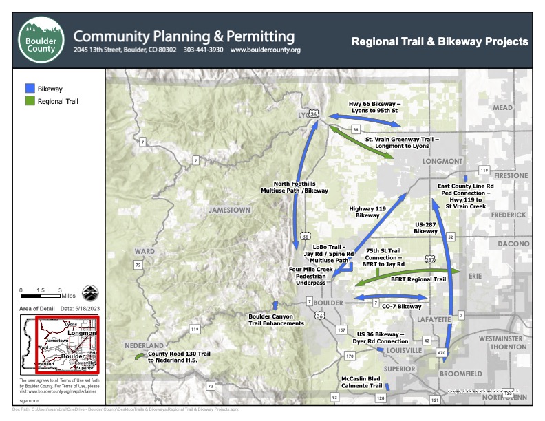 From about 2023, this graphic shows part of Boulder County’s methodical approach to network multi-modal planning and design. It’s a great plan, it just needs to be funded.