CDOT issued its draft 2050 Plan and its draft Active Transportation Plan. The Denver Regional Council of Governments issued its draft Active Transportation Plan. C4C’s comments in response to these plans are below the following background and discussion.
The problem in transportation is that there is not enough money in the first place and what money there is does not flow fast enough. One of the many consequences of this is that state level departments of transportation like CDOT make plans that end up being more for reference than for executing.
The solution is improved planning standards and design guidelines that compensate for budgeting realities. It’s urgent because as long as the current transportation conditions persist, the traffic related serious injuries and fatalities will continue. It’s important because we know that design determines outcomes and in order to improve outcomes, we have to improve the adoption of leading design standards.
C4C’s comments on plans like the ones in question are aimed at shifting from plans for reference and towards plans for execution. The way that C4C proposes doing this is to take a page out of the City of Boulder’s book. The City of Boulder’s Core Arterial Network Project concedes that the city could spend its entire transportation budget on maintenance alone. In order to balance the overall funding shortfall, the city has planned, designed, and implemented improvements on an incremental basis at a pace that is affordable. Those plans are all part of a connected network that can serve as a beginning for subsequent planning, design, and construction because we know that planning in segments does not work.
Next, C4C proposes taking a page out of Boulder County’s book. Most state departments of transportation design right-of-way (the public land for connecting communities) for roadway use. We know that roadways have limited utility and adverse costs. Boulder County, conversely, makes all its plans at a county-wide scale and to design standards that are network multi-modal. That means right-of-way is designed for multiple ways for people and goods to move and all those modes are connected at a network level and in partnership with municipalities in Boulder County.
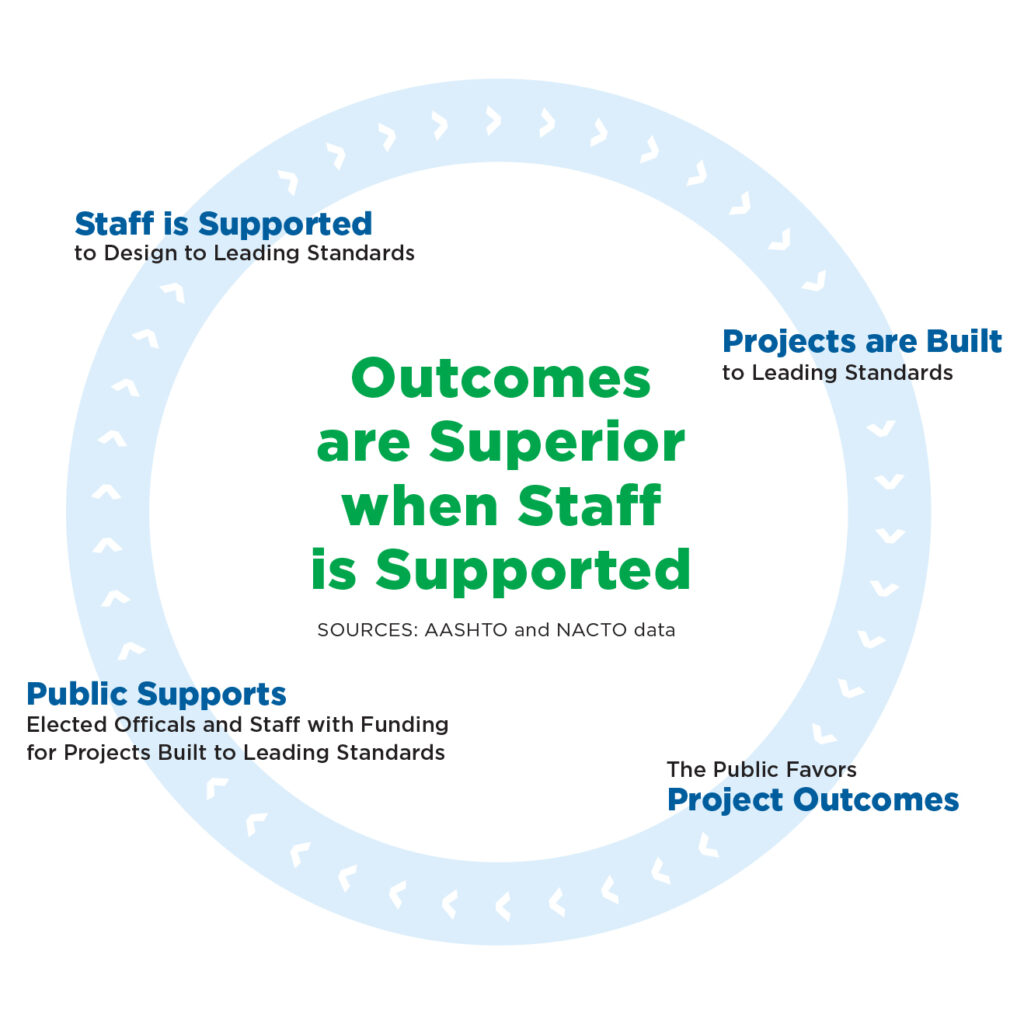
AASHTO and NACTO data shows that outcomes are superior when staff is supported to design to standards. When design is at or below minimal standards, there should be a complement in the network. Doing so shifts transportation from being a tax to being an investment whose value is mobility, safety, and comfort for all. That’s what Boulder County does and its electorate supported the 2022 one penny on $10 transportation sales tax at a rate of 81% in favor.
 100 years of roadway use of right-of-way is not going to change overnight. It will change by supporting leading design standards over the long-term.
The challenge is to support elected officials and staff in planning, designing, and incrementally building good or even great infrastructure accompanied by sensible policy. It’s not untenable. It’s happening right now on Highway 119 The Diagonal between Boulder and Longmont where it took 15 years to obtain the full $165M to build a great project. It’s the product of the partnership between CDOT who manages the right-of-way and Boulder County who brought its design experience rooted in its residents’ needs, its surrounding and connecting rights-of-way, and its additional funding capacity to the project. The result is excellence.
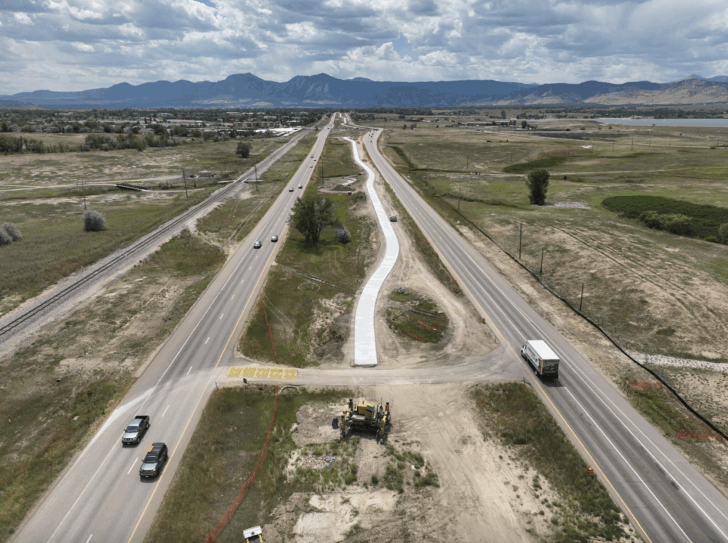
The Highway 119 Boulder – Longmont Project is a model for good design. No added general purpose traffic lanes; roadway safety improvements; bus rapid transit designed to be fast, frequent, and easy; safe and appealing bike-ped access; future connections to passenger rail; and all of it connected on a network level.
C4C’s Response to the Draft CDOT 2050 Plan
Coalition 4 Cyclists, 501c3, supports the principles of maintenance, safety, and mode choice. For C4C, maintenance is paying for the system we already have. Does it make sense to communicate to the public the discrepancy between available funding and needed maintenance?
Safety, for C4C, is evidence based interventions where the data indicates the need. With improving crash data, does it make sense to more clearly communicate an intervention based plan to fix adverse safety outcomes?
Mode choice is, for C4C, a matter of improving planning. Is it possible to plan by designing all projects to network multi-modal standards in the first place so they start at the network level with modal choices? This is already happening as a product of the partnership between CDOT R-4 and Boulder County. Maybe this partnership could be adapted across Colorado’s diverse transportation regions and scaled for broad and shared benefits.
Missing Elements
1.) Page 40 “Land Use Decisions Affect Transportation” could be more accurate, no? Isn’t this relationship mutual? That is, we know that the design-use of right-of-way affects land-use. Right-of-way markets and land-use markets are tied. Here’s how C4C sees it, the design-use of right-of-way has cost outcomes in a.) Mobility – congestion b.) Land-use – sprawl c.) Water conservation – scarcity d.) Safety – excess killed and seriously injured well above the rates of peer nations e.) Opportunity – freedom of movement resulting in health and full human lives f.) Emissions for health – for example, the cost of adverse cardio-pulmonary outcomes g.) Emissions for climate – a warming planet, wildfire, etc. h.) Environment – for example, habitat connectivity i.) Equity or taxpayer fairness – building good infrastructure for all Coloradans
2.) How is the PACE Tool related to the design of right-of-way? Design determines outcomes and we know that users do not travel in segments. Rather, users travel in networks and their mobility is improved when they have mode choice that is conditioned positively by the design of right-of-way.
Final Thoughts
1.) Thank you for mentioning crash data on page 67. Maybe DRCOG could be supported in their exploration of a statewide standardized electronic crash report system. I think DRCOG sometimes calls it a unified crash report system. Standardizing crash reporting would support Colorado’s 220+ law enforcement agencies, multiple contractors, CDOT, and the DOR. It would standardize best practices, procedure, response, reporting, analysis, and other things. It would save money as was the case in Texas. Most of all, it would shift crash data to its elevated role of explaining preventative crash response in place of describing past events.
2.) Regarding PD 14, these are good goals. Alternatively, maybe there could be causal measurements in addition to the reactive data shown. That is, would it work to add measures in each categories that drive desired outcomes in addition to the metrics that measure what already happened?
To be critical and use jargon, there’s a Goodhart’s Law problem here. PD-14’s measures, it could be said, have become distinct from what they’re intended to represent.
If I could make Wildly Important Goals, I’d propose, a.) Percentage of Coloradans within 10 minutes of a multi-modal/path/trail facility in a network that gives them safe and appealing access to work, services, and play. b.) Change in number of projects done in partnership with county and municipal governments where roadway and multi-modal use of right-of-way are managed comprehensively. c.) Communication tools that show why instead of improvements, we need to pay for maintenance. Why instead of improvements, we need to pay for safety interventions. And, what the cost of outcomes are related to the roadway use of right-of-way versus the multi-modal use of right-of-way in a network level system. Thanks for all your work on these topics, Matt Muir, C4C
C4C’s Response to CDOT’s Draft Active Transportation Plan
CDOT Statewide Active Transportation Plan Public Comment
General Impressions
SELECTED – The plan somewhat reflects the needs and priorities of my community.
Tell us about how the plan does or does not reflect the needs and priorities of your community.
For Coalition 4 Cyclists (C4C), the hope was that the Active Transportation Plan would provide an outline of a bicycle and pedestrian network on a statewide scale.
The opportunity was to partner with transportation planning regions, counties, and municipalities on a comprehensive approach to the planning and design of right-of-way according to network multi-modal standards.
Vision and Goals
The Active Transportation Plan includes the following vision for walking, biking, and rolling in Colorado:
Colorado’s active transportation network is well-connected, comprehensive, and convenient – our bikeways, sidewalks, and trails get people where they want to go. This system offers everyone the opportunity to safely and confidently rely on or choose active modes over driving, in turn improving transportation sustainability, reducing car dependency, and mitigating traffic congestion. Enhancing our active transportation network will enhance quality of life for all Coloradoans.
How well does the plan’s vision align with what you’d like to see for walking, biking, and rolling in Colorado?
SELECTED – Neutral
Colorado’s Active Transportation Vision is supported by four core plan goals, each of which are supported by associated strategies and performance measures in the plan:
Safety: Enhance the safety of active transportation users by reducing crashes, injuries, and fatalities.
Equity: Ensure equitable access to safe and convenient active transportation facilities for all communities, particularly underserved and vulnerable populations.
Mobility Choice: Increase the availability, accessibility, and convenience of active transportation to create a complete network that provides sustainable and affordable alternatives to driving and improves air quality.
Connected Communities: Promote connections among active transportation, transit, and the built environment to maximize the impact of investments in active transportation infrastructure and programs.
How much do you support each of the plan’s goals for walking, biking, and rolling in Colorado?
Are there any goals or topics you feel are missing or need more attention?
Can it be demonstrated how the ATP is related to safety, equity, mobility choice, and connected communities through planning, the design use of right-of-way, and funding for execution of those goals?
Design determines outcomes and while the PACE tool is a nice idea for placing projects in an order, the ordering of projects is less important than showing how projects will be planned and designed to network multi-modal standards.
Strategies and Performance Measures
Are there any strategies, recommendations or performance measures that you support?
On their own, the strategies, recommendations, and performance measures are a good start. However, it needs to be shown how they will be funded and executed in the context of CDOT’s overall operations.
Are there any strategies, recommendations or performance measures that you have concerns about?
Unless they are tied to improved planning, design-use of right-of-way, and support from local partners; then there is concern about all of them.
Regarding the PACE tool, it is a tool that measures segments of existing roadways. Maybe it makes more sense to use measurements of right-of-way in addition to roadway. Measuring right-of-way supports planning and design to network multi-modal standards and in partnership with local agencies.
Final Thoughts
Is there anything else you’d like to share with us about the draft Active Transportation Plan?
Here’s what Coalition 4 Cyclists (C4C) would propose.
1.) Ask the stakeholder group two questions.
a.) What active transportation priorities their organizations have in their areas?
b.) What role they would like CDOT to play in active transportation planning?
2.) By partnering with local agencies, the ATP process would shift from a top-down plan limited to CDOT right-of-way to a collaborative process using rights-of-way across agencies.
3.) If Appendix A could be shared publicly, that would help all the partners to participate and comment on named, specific projects in order to produce a better debate and conversation about how to proceed.
4.) The ATP process is a good opportunity to educate on best practices across Colorado’s diverse TPRs. For example, the partnership between CDOT and Boulder County on the execution of Boulder County’s network multi-modal Transportation Master Plan could be shown.
5.) In engineering terminology, the ATP is an opportunity for CDOT and its contractors to standardize planning and design to AASHTO and NACTO guidelines. The data shows that when staff is supported to design right-of-way to AASHTO and NACTO standards, outcomes are superior. When those standards are at or below a minimum, the prescription is that there be a complementary facility in the travel network.
6.) The ATP is an opportunity to be technically precise with terminology. For example, “bike lanes” is a phrase that gets used a lot. Bike lanes are a part of a system. The goal is to achieve the whole system with all of its parts.
7.) Replace problematic models like “perceived stress” or Level-of-Traffic-Stress with better measures. A novice or advanced vulnerable user are both equally subject to the lethal kinetic energy of a roadway.
8.) It would be helpful if staff and contractors were supported to be consistent in their treatment of design standards. For example, in the first meeting, the contractor devoted discussion to rural mid-block or roadway segment collisions and their role in adverse safety outcomes for bike-ped users. In the last meeting, lane deviations [lane or roadway departures] were classified as a level of detail not contained in the draft plan. These two discussions contradict each other.
Lane deviations and roadway departures are a significant contributor to the nation’s worst by a margin rate of traffic related killed and seriously injured, a rate that is disproportionately high among bike-ped users.
By addressing the mechanism of injury and its causal relation to indicated design improvements, it’s feasible to address the excess number of seriously injured and fatalities that, if left as is, represent a problem for C4C.
9.) The ATP is an opportunity to integrate planning, design, and funding together. For example, if every project is designed to leading standards and each project flows into funding with active transportation components in the design, then there are better outcomes.
10.) The ATP is an opportunity for CDOT’s grant writing assistance to aid under-resourced TPRs in designing with leading standards instead of roadway standards.
11.) Consider the ATP relative to the list below of CDOT plans that could, perhaps, be simplified for the sake of utility, accountability, and execution.
The Statewide Transportation Plan
2050 Plan (there was a a 2045 Plan also)
The Governor’s 2035 Transportation Vision
The State Transportation Improvement Plan (consumes large budget sums for roadway projects)
The 10 Year Plan (mostly roadway plans)
Regional 10 Year Plans
The Active Transportation Plan (a $0 budget plan with over 60 strategies)
The Highway Safety Improvement Plan
The Colorado Strategic Transportation Safety Plan (contains 15 Tier One strategies and more lower tier strategies some of which are good but need to be executed)
The Roadway Design Guide (608 pages)
The Non-motorized Monitoring Strategic Plan
High Demand Bicycle Corridors
Colorado Downtown Streets
CDOT Region 1 and Region 4 Bicycle and Pedestrian Safety Assessments
Curb-ramp Accessibility Initiative and ADA Transition Plan
Vulnerable Road User Safety Assessment
Pedestrian Crossing Installation Guidelines and Pedestrian Signal Timing Guidelines
The CDOT Project Development Manual
Policy Directives 1601, 1602, and others
Revitalizing Main Streets, Multi-modal Mitigation and Options Fund Programs (relative to other budgets and roadway funding)
Safe Routes to School Program (oversubscribed)
GHG Planning Standard (regularly out of attainment)
Plans in conflict like the West Connect Planning and Environmental Linkage Plan, Jefferson County’s developing and related plans, and the Boulder County Transportation Master Plan
C4C’s Response to the Draft DRCOG Active Transportation Plan